$
12.95
$
12.95
ADD TO CART
BUY IT NOW
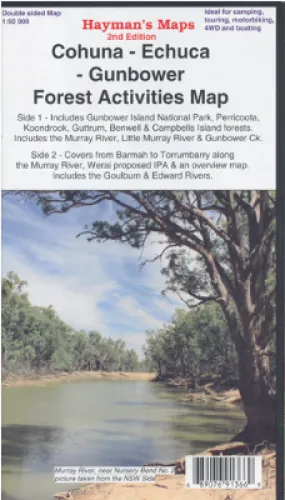
Cohuna Echuca Gunbower Map Hayman
Including the Murray River Red Gum Forests, Perricoota, Koondrook, Campbell’s Island, Guttrum, Benwell & Werai State Forests.
The map is a large double sided map with photographs and notes. One side is a 1: 50 000 map covering the region bounded by Torrumbarry Weir in the south and Murrabit in the north. The Gunbower National Park and State Forest and Perricoota and Koondrook forests are covered in detail. Also Murrabit, Cohuna, Leitchville, Gunbower, Mead
Side two contains several maps.
The main map is a 1: 50 000 map covering from Barmah to Torrumbarry, there is a 1: 75 000 map of Werai State Forest to the NW of Deniliquin and an overview map (1: 350 000) showing how the maps link together and access routes to the areas. Suitable for camping, touring, 4wd, fishing, boating, walking tracks and much more including Moama, Lower Moira, Yambuna, Barmah Kanyapella Game Reserve, Barnes
- Scale: 1:50 000 main map
- Scale: 1:75 000 inset map
- Updated: 2014
- Double sided with overlapping panel
- Suitable for use with GPS
- Extensive 4wd tracks coverage
- Walking tracks and campsites
- Map Size: 100cm x 70cm approx
- Colour with contours, photographs & notes